
For 5 days more is going to “insist” stormy winds across the country and reach up to 9 beetle in the Aegean. This is expected that the August licenses will find it difficult to get out of the port of Piraeus and the rest of the islands, and the risk of fires increased.
Tomorrow Friday (08.08.2025) the winds will blow north -northeast, west 4 to 6 and east 6 to 7 and in the Aegean 8 local 9 beaufort. The temperature will not make a significant change and will reach 34 to 36 and locally on the western continents 37 to 38 degrees, while in the Cyclades, Sporades and northern Crete will not exceed 30 to 31 degrees Celsius.
Live the evolution of winds
Increased risk of fire
An alarm has been sounded in the state mechanism, as there is an extreme risk of fire on Friday due to wind reinforcement. The North have already been reinforced in the Aegean and east since Thursday, and according to the NMS, the stormy winds will reach 8 and local 9 beaufort in the Aegean on Friday.
The winds will blow up at least until Sunday. In fact, the Superjet did not sail from Paros on Thursday afternoon due to strong winds.
Meteorologist Giorgos Tsatrafyllias post on Facebook does not exclude the winds on Friday the winds will exceed 100 kilometers per hour “and to create local storms” in:
- Doro
- South Euboean
- Northern Cyclades
- Carpathian sea
- West – south of Crete
“It is advisable for the aspiring travelers tomorrow from the ports: Piraeus, Rafina, Lavrion for the island areas and from them, to contact the local Port Authorities. Also secure objects (antennas, pots, awnings, etc.) for any accidents in Attica, Evia Cyclades, eastern Peloponnese. The stormy winds with fluctuations will be maintained until the eve of Augustus, ”concludes George Tsatrafyllias.
Lycabettus closed
All the departments of the Municipality of Athens were raised on the alert due to the very high risk of fire due to strong winds.
Also, the Lycabettus hill closes for each activity tonight at midnight – to newer information – based on the projected measures in alarm situations, which are valid tomorrow in Attica (Friday 8 August, risk category 5).
According to the Civil Protection Plan, alert and green workers have been formed, and aquifers are on the alert. Municipal police with constant patrols and use of drones controls hills and large green areas in the city center. Also, the Business Center of the Service will operate on a 24 -hour basis for the information and assistance of the Fire Brigade, as well as other services and municipalities.
Finally, citizens are invited to be very careful, and in any indication of danger to communicate with the authorities.
Specifically extreme risk of fire – Alarm status (risk category 5) is foreseen tomorrow for the following areas:
- Attica Region (including the island of Kythera)
- Region of Central Greece (Boeotia, IP of Evia)
- Peloponnese Region (IP of Argolida, Corinthia PE, IP of Laconia)
Very high risk of fire (risk category 4) for the following areas:
- Region of Western Greece
- Peloponnese
- Ionian Islands Region (Zakynthos)
- Region of Central Greece (PE Boeotia, PE Fthiotida, IP Fokida, Evia IP including the island of Skyros)
- Region of Thessaly (Magnesia)
- Northern Aegean
- South Aegean Region (Cyclades Regional Units)
- Region of Crete
- Region of Eastern Macedonia and Thrace (Rodopi, IP Kavala, IP Thassos, IP Xanthi, Evros IP including the island of Samothraki)
- Region of Central Macedonia (Halkidiki IP, including Mount Athos)
- Epirus Region (Preveza IP)
Stormy winds and worsening of pyrbetorological conditions
The northern winds will be significant in the Aegean and eastern continents from Thursday 07/08 to at least Sunday 10/08, with a significant exacerbating pyrological conditions.
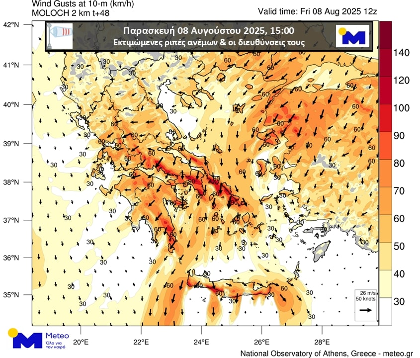
Specifically, according to the prognosis of the National Observatory of Athens/meteo.gr, the gusts of the winds at noon on Thursday 07/08 in eastern Sterea will reach 80 km/h, while in southern Evia, in the Cyclades and southern Crete. According to available prognosis, on Friday 08/08, further reinforcement of the northern winds is expected, with their puffs in eastern Solidarity, South Euboea, Cyclades and locally in southern Crete reaching 100 km/h, as clearly reflected in the map below 1.
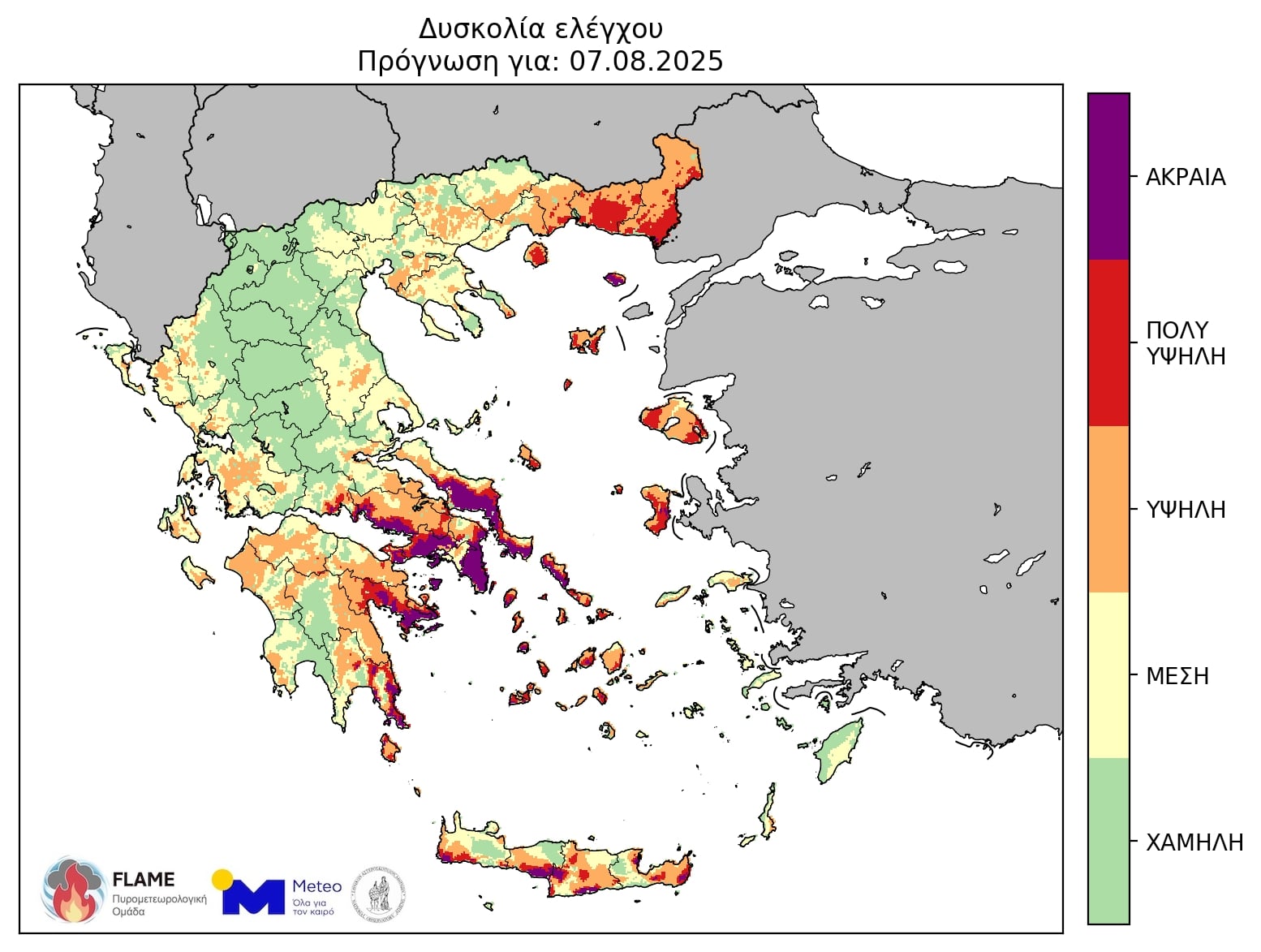
It should be noted that due to the reinforcement of winds, the pysterological conditions will worsen in the eastern sections, with the main features:
- Very high potential for wind -guided forest fires with potentially high thermal loads to the east and south.
- Significant increase in difficulty in the case of fires in the east and south, mainly in areas where rains have not occurred in recent days.
The following map group shows the estimated control difficulty in accordance with the Canadian Forest Weather Index System – CFFWIS, adapted to the Greek environment of Greece during Thursday 07/08 and Friday 08/08/2025.
Detailed Forecast of the NMS for Friday (8/8/25)
Generally cloudy weather with temporary clouds in northern Crete and noon – afternoon in the mountains of western and central Macedonia where local rainstorms are likely to occur.
The winds will blow north -northeast, west 4 to 6 and east 6 to 7 and in the Aegean 8 local beaufort. The temperature will not make a significant change and will reach 34 to 36 and locally on the western continents 37 to 38 degrees, while in the Cyclades, Sporades and northern Crete will not exceed 30 to 31 degrees Celsius.
MACEDONIA, THRAKI
Weather: Generally cloudy with temporary clouds in the afternoon – afternoon in the mountains of western and central Macedonia where local rainstorms are likely to occur.
Winds: northeast northeast 4 to 6 and east maritime sections 7 beaufort.
Temperature: from 20 to 35 and locally 36 degrees Celsius. In Western Macedonia 2 to 3 degrees lower.
Ionian Islands, Epirus, Western Solid, Western Peloponnese
Weather: Generally cloudy with temporary clouds in the midday – afternoon hours in the mountains of Epirus.
Winds: northeast northeast 4 to 5 and in the Ionian local 6 beaufort.
Temperature: from 20 to 34 and continental local 37 to 38 degrees Celsius. Inside the continent the minimum 3 to 4 degrees lower.
THESSALIA, EASTERN Solid, EVIA, EASTERN PELOPONNESE
Weather: Generally cloudy.
Winds: northeast northeast 4 to 6 and east 7 local 8 beaufort.
Temperature: from 21 to 35 to 36 degrees Celsius.
CRETE, CRETE
Weather: In the Cyclades generally cloudy. In Crete transient clouds until the afternoon, with the possibility of weak local rain in the north.
Winds: Northeast northeast 6 to 7 and in the Cyclades 8 local in northern 9 beaufort.
Temperature: from 24 to 30 to 31 and locally in southern Crete 34 degrees Celsius.
EAST ISLANDS – DODECANESEA
Weather: Generally cloudy.
Winds: From northern shocks 5 to 7 and northern local 8 beaufort.
Temperature: from 24 to 35, locally 36 degrees Celsius.
ATTICA
Weather: Generally cloudy.
Winds: northeast northeast 5 to 7 and east local 8 beaufort.
Temperature: from 24 to 34 to 35 degrees Celsius.
Thessaloniki
Weather: Generally cloudy with a few clouds early in the morning and again at noon – afternoon.
Winds: from northern addresses 4 to 5 beaufort.
Temperature: from 21 to 34 degrees Celsius.
Prognosis for Saturday (9/8)
Clear weather.
The winds will blow from northern directions, west 4 to 5 and in the Ionian local 6 beaufort, east 6 to 7 and in the Aegean local 8 and in the sea of Kythera in the early hours of 9 beaufort.
The temperature will not note a significant change. It will reach 34 to 36 and locally on the western continents 37 to 38 degrees, while in the Cyclades, Sporades and northern Crete it will not exceed 30 to 32 degrees Celsius.
Prognosis for Sunday (10/8)
Clear weather.
The winds will blow from northern directions, west 3 to 5, east 6 to 7 and in the Aegean local 8 beaufort.
The temperature will rise slightly.
Prognosis for Monday (11/8)
Clear weather.
The winds will blow from northern directions, west 3 to 4, in the Ionian Sea 5, east 5 to 7 and up to 8 beauforts locally.
The temperature will not note a significant change.
Prognosis for Tuesday (12/8)
Clear weather.
The winds will blow from northern directions, west 3 to 4, in the Ionian Sea 5, east 5 to 7 and possibly in the northern Aegean local 8 beaufort.
The temperature will not note a significant change.