
In full swing is the bad weather that struck from early Monday morning (31/03/2025) the Cyclades And it caused severe problems in Paros and Mykonos.
The torrential rains brought by bad weather that will hit the country until Wednesday (02/04/2025) caused large floods in Paros and Mykonoswhile other islands in the Cyclades also faced problems.
It is characteristic that Schools stay closed tomorrow Tuesday 1st April in Paros, Mykonos Rhodes and Symi For preventive reasons while the Peloponnese and the Peloponnese has been affected Western Greece with intense hailstorms.
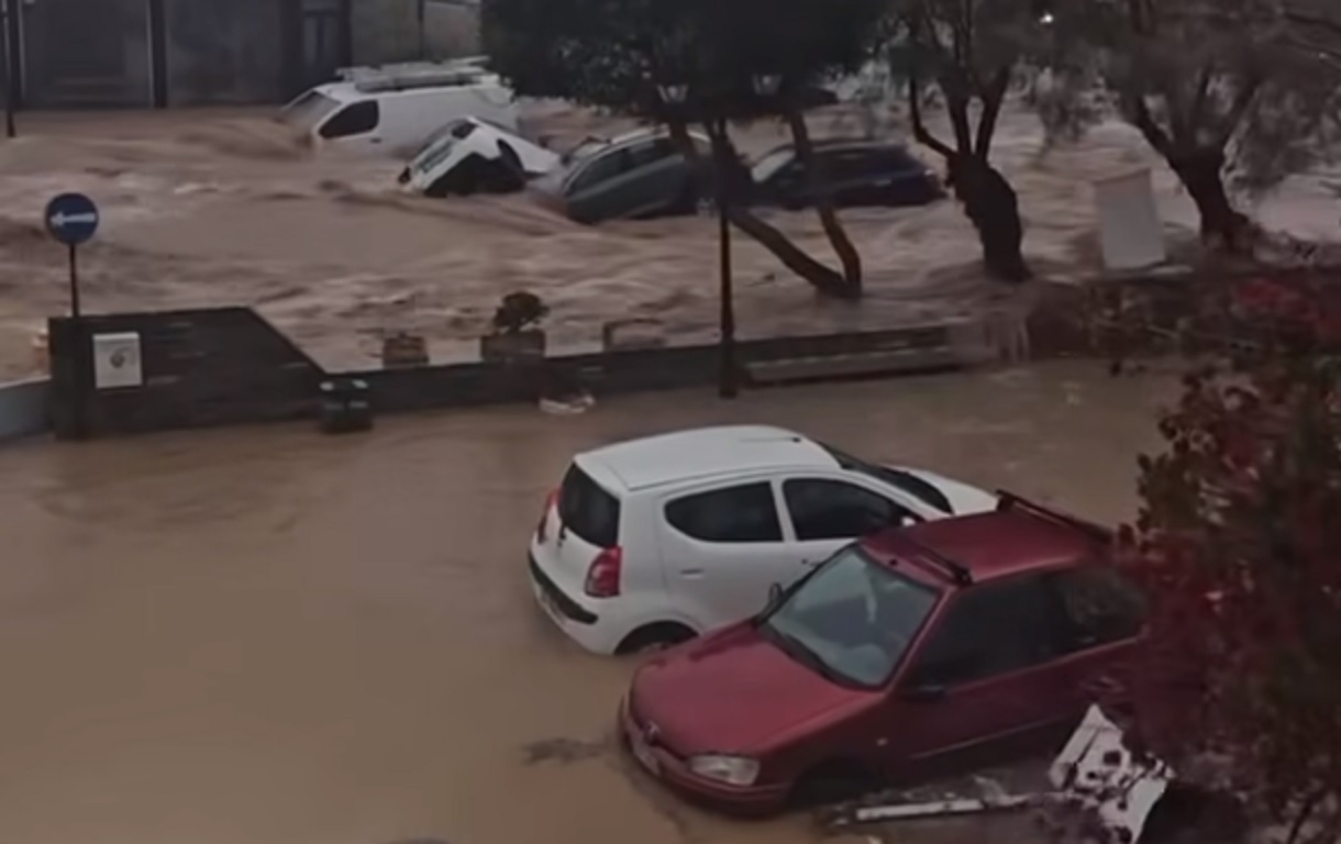
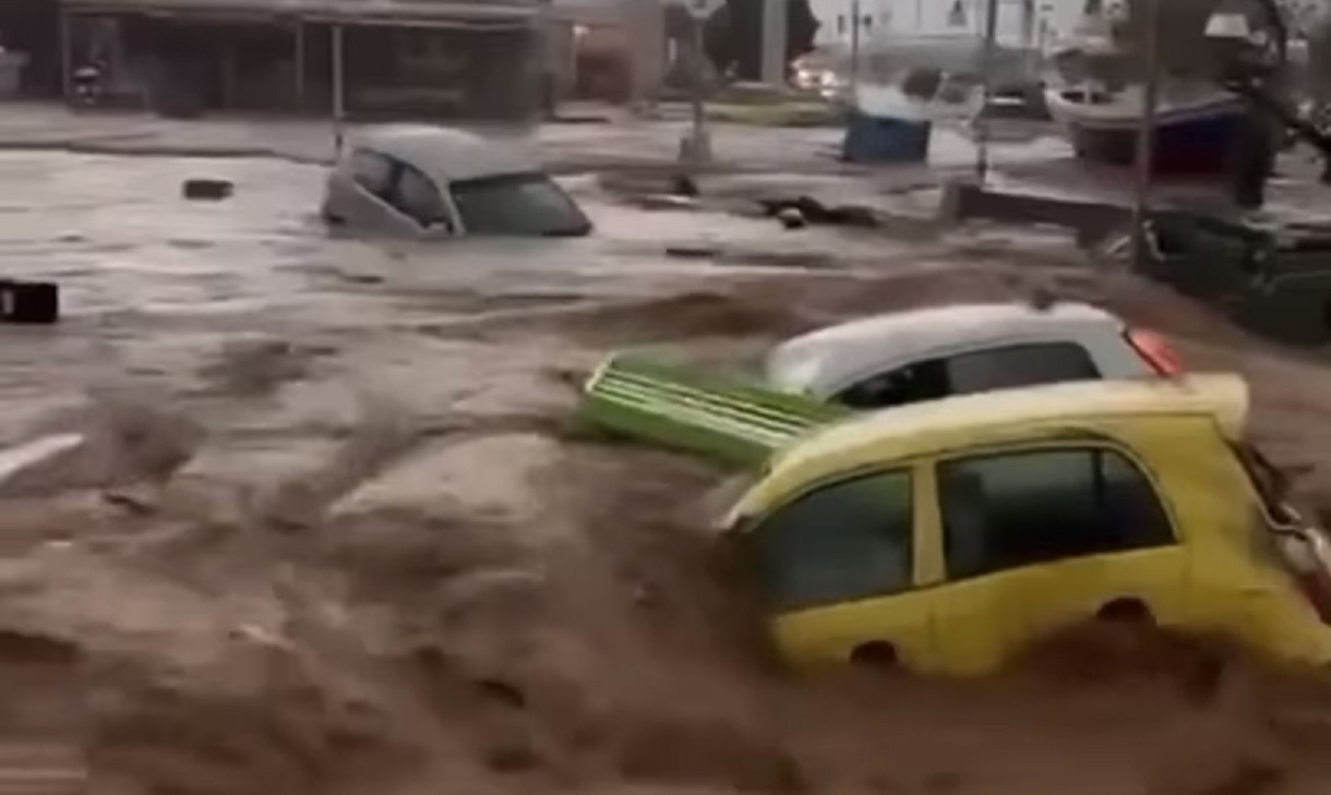
Roads and houses flooded in Paros and Mykonos with the Fire Department proceeding to water pumps and in people’s transport to safe spots.
In particular the fire brigade He has received 100 calls to Mykonos While they have so far have taken place Five water pumps.
To strengthen the forces on the island of Mykonos, 2 firefighters with 1 vehicle and 4 firefighters with 2 vehicles go from Tinos.
To Paros Fire Brigade received 60 calls While so far they have been carried out Eight Water Pumps and 13 Transfers of People to Safe Points.
To strengthen the forces on the island of Paros, 6 firefighters with 3 vehicles were transferred from Naxos.
At the heart of the bad weather was the island of Paros, mainly the Naoussa area as Roads flooded, creating rushing torrents that dragged vehicles and caused great material damage.
Initially the bad weather passed from Syros without causing particular problems, followed by Paros, which had the greatest disasters and then Mykonos.
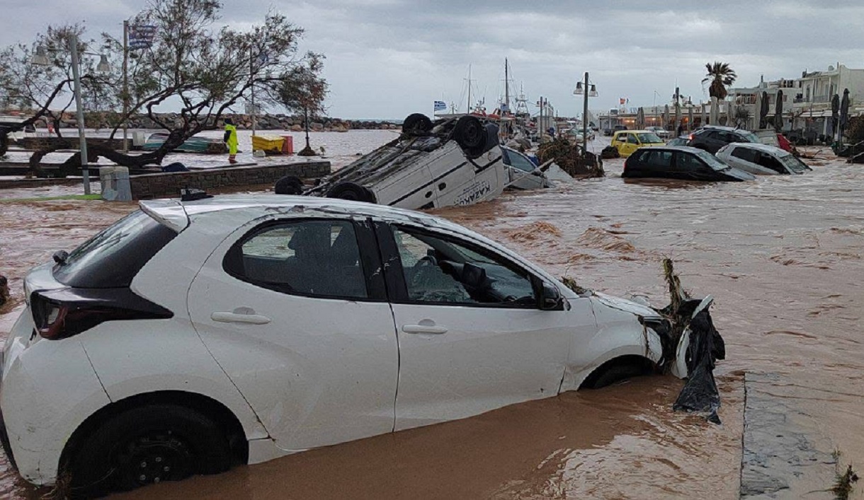
In 112 he sounded for the Cyclades and then in Paros and Mykonos where the movement of vehicles on the roads are prohibited. In Mykonos, the streets of the city have been flooded while torrents have formed waterfalls in areas such as Tourlos on the island of winds.
Helicopter with firefighters tried to reach Paros
Police forces in the Cyclades have also been put on the alert, and the Armed Forces are also on the alert, and in particular the administration of construction and treatment of natural disasters (DIKAFKA), if requested to assist.
The helicopter who had left Athens to Paros with 8 firefighters to reinforce their colleagues was forced to cancel his mission and returned to Athens, as they encountered extreme weather events on the route that made the flight dangerous and eventually transported by Naxos.
Comes ‘Storm Triangle’ in the Aegean
The situation will remain difficult in the Cyclades all night, according to Thodoris Kolidas who called on the world to be very careful.
Indeed, as he pointed out in the Star Central Newsletter, bad weather during the night will expand north and hit Tinos and Mykonos, where there are already problems.
“Imagine an imaginary triangle between Tinos-Andros-Chios-Samos and Ikaria. The thunderstorms will be mainly in the Aegean and will also affect the Dodecanese, ”said Mr. Kolidas and called on the inhabitants to be vigilant.
“The Aegean lifts the burden of all bad weather – a strong storm cluster that moves very slowly to the north.”
According to ERT meteorologist Nikoleta Ziakopoulou, the Aegean lifts the enormous weight of all bad weather. “In the heart of the Aegean there is a powerful thunderstorms, which moves very slowly to the north and passes through, it scans, giving huge rapids, water within 2 hours that would normally fall into 2, 3 and 4 months. That’s why we had the disasters. “
At the same time he pointed out that there will be a recession of phenomena in the areas that have already been hit, but there should be no complacency because “in the night we are likely to have new storms strong, so there must be care”.
He also stressed that the thunderstorms is moving slowly to the north, so the Cyclades take a breath, but other areas, mainly the Aegean, will be threatened.
“Storms are approaching Chios. I appreciate that we will have strong phenomena within a short time. Beyond that we will have rains not only in the eastern – northeast Aegean, but also in Sporades, Thessaly, Euboea and a piece of Eastern Solidarity. In the Dodecanese the winds will be stormy 8 and 9 beaufort. There in the night we will have very strong winds of wind with potential problems on both flights and transport. The winds will be cut tomorrow morning, but the storms will come.
It is almost certain that it will find again in Paros not with greater intensities (…) it will find again in the Cyclades and Attica from time to time with a volatile weather with intervals of strong thunderstorms that will last and employ us at least until Wednesday. Gradually from noon on Wednesday onwards, there will be a fading, but we have spring, instability is here and we will have thunderstorms all the coming days, ”Ms. Ziakopoulou concluded.
The EMY Extraordinary Bulletin
According to the emergency report of dangerous weather issued on Sunday (30-03-2025) and local rains and thunderstorms are updated from the Monday Monday Hours (31-03-25) until Wednesday morning (02-04-25).
Specifically:
A. In the Cyclades from Monday afternoon (31-03-25) until noon Tuesday (01-04-25). The phenomena will be locally dangerous-red warning-until the morning of Tuesday (01-04-25).
B. in the islands of the Eastern Aegean (mainly Samos-Ikaria-Chios area) from Monday night (31-03-25) to Tuesday night (01-04-25).
C. In Eastern Solidarity and Euboea from Monday night (31-03-25) to noon on Tuesday (01-04-25).
D. In Attica Monday night (31-03-25) to Tuesday (01-04-25).
E. in Thessaly and the Sporades from the early hours of Tuesday (01-04-25) to the evening of the same day.
F. In the Dodecanese from the morning of Tuesday (01-04-25) to the morning hours of Wednesday (02-04-25).
G. In West and Southern Crete from the evening of Tuesday (01-04-25) to Wednesday morning (02-04-25).