
At the mercy of transient bad weather Western Greece was found on Saturday (30.08.2025), after strong winds were marked, severe storms And hailstorms mainly in Corfu, Kozani and Grevena, causing serious problems.
The bad weather is expected to insist today in some areas, with rains, thunderstorms and local hailstorms in the west, central and north with gradual improvement in all areas. According to yesterday’s EMY Extraordinary Weather Bulletin, in the areas of Corfu, Paxos and Epirus, heavy rains and thunderstorms are foreseen in the early morning hours.
Temperatures will range in western Macedonia from 14 to 28 degrees, in the rest of Macedonia and Thrace from 15 to 30-32, in central Greece from 21 to 34-36 degrees, in Epirus from 19 to 28 degrees.
In the rest of the continents from 18 to 32-34 and locally east to 35-36 degrees, in the Ionian Islands from 17 to 28-29, in the Aegean islands and Crete from 17 to 28-30 degrees, while locally in the islands of the Eastern Aegean and Crete the maximum will reach 33-34 degrees.
The winds in the southern Aegean will blow west with 4-5 beaufort tensions and local 6 beaufort, while in the rest of the Aegean will blow south winds with up to 5 beaufort. The Ionian will blow northwest winds with 4-5 beaufort tensions. Western stream with 5-6 beaufort will prevail in the Corinthian Gulf.
In the prefecture of Attica and in the city of Athens we expect few. The winds will blow from western directions with tensions of up to 4 beaufort and locally in the western part of the county 5-6 beaufort. The temperature will range from 23 to 34-35 degrees.
In Thessaloniki we expect rains and thunderstorms that may be intense and accompanied locally by hailstorms. In the afternoon, however, the weather will improve. The winds will blow from northwest directions with intensities of 3-4 beaufort. The temperature will range from 22 to 30 degrees.
See Live the storms and course of temperatures
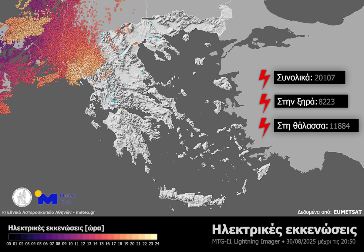
More than 20,000 lightnings by Saturday night
According to Meteo, rains and thunderstorms occurred in Corfu, Epirus and areas of Western Macedonia from noon to the early night of Saturday, August 30, 2025.
The data analysis by the European Meteosat-12 Meteorological Satellite and the Lightning Imager (LI) body has shown that by 21:00 on the night of Saturday, August 30, 2025, more than 20,000 electric dismissions have been recorded in the aforementioned areas.
It is noted that as electrical evacuations we define all of those that include lightning (discharges between clouds and soil), electrical discharges between clouds and electrical discharges between clouds and the surrounding air.
The storm in Corfu was very strong and presented overshooting by 11.24 ° C
In his post, meteorologist Theodoris Kolidas states that the phenomena had very strong vertical growth and intense electric/power supply.
These are in line with the image of powerful overshooting tops, which creates strong winds, pressure fluctuations, electric loads and extreme quartz or hydrrosobils.
His references @Starchannelnew1 They talk about uprooted trees in western Macedonia, a falling platform in Ioannina and even a hydrostatic – an indication that the phenomena had very strong vertical growth and intense electric/power supply. From the meridian newsletter …
– Theodoros Kolydas (@kolydast) August 30, 2025
In his other post, the meteorologist noted: “The storm in Corfu was very strong and presented overshooting by 11.24 ° C which means that the top climbed about 1–3 km above tropsis. The value -11.24 ° C refers to the temperature difference between the cloud temperature (at its top) and the ambient temperature at the height of the tropose. That is, the cloud is 11.24 ° C cooler than tropopause. This translates to significant exceeding: Usually such deviations correspond to peaks that have risen 1–3 km above tropose.
So the storm did not stop at tropsis but continued strongly higher, penetrating the stratosphere, because the strong updraft had enough momentum to overcome the “lid” of the atmosphere.
Why is this happening
In very strong thunderstorms (supercells, mesoscale convective systems) the thermal upload is so strong that the upward movements “pierce” tropsis. Although the stratosphere is a fixed layer (temperature increases with height), the updraft has such kinetic energy to cause transient penetrations. The phenomenon is associated with intense electrical activity, strong winds, hail and sometimes creation of gravity waves spreading in the stratosphere. “
“The storm in Corfu presented overshooting by 11.24 ° C”
In his post, meteorologist Theodoris Kolidas states that the phenomena had very strong vertical growth and intense electric/power supply. These are in line with the image of powerful overshooting tops, which creates strong winds, pressure fluctuations, electric loads and extreme quartz or hydrrosobils.
The strong storm in northwest 30-8-2025
The storm in Corfu was very strong and showed overshooting by 11.24 ° C which means that the top climbed about 1–3 km above tropose. The value -11.24 ° C refers to the temperature difference between… pic.twitter.com/GQXhweXeu3– Theodoros Kolydas (@kolydast) August 30, 2025
Hail and severe thunderstorms “hit” western Greece
A torrential rain yesterday in Corfu caused serious problems, with many roads flooding both in the historic center of the city and in the surrounding areas.
At the same time, the power grid was damaged, leaving the city center for several hours without electricity and several villages in northern Corfu.
The bad weather on air transport also had a serious impact, as due to heavy rainfall, intense lightning activity and low clouds, no take -off or landing at the island’s airport was carried out.
Serious problems were also found in Grevena, where part of the city, as well as many areas along the Grevena-Tsotyli line, were left without electricity due to falling trees in DEDDIE pillars. The affected areas include Tsotyli, almonds, the link, the Kydonias and other villages of Grevena and Vojos Kozani.
According to forecasts, locally heavy rains and thunderstorms are expected in the areas of Corfu, Paxos and Epirus in the early hours of the morning.
Prognosis for today Sunday (31/08)
In the western and northern country clouds in places increased with local rains and sporadic storms, locally strong in the early morning hours in the areas of Corfu Paxos and Epirus. It is expected to improve weather in the afternoon. In the rest of the country generally cloudy weather with temporary clouds in the continents until the afternoon where local rains will occur.
The winds will blow southwest southwest 3 to 5, locally in the southern Aegean 6 and from noon to the west northwest 4 to 5 beaufort.
The temperature will drop to the west and north. It will reach the west and northern continents and the Ionian islands 30 to 32 degrees, in their other continents 34 to 35 degrees and in the rest of the island country 32 to 33 degrees Celsius.
MACEDONIA, THRAKI
Weather: In western Macedonia clouds with local rains and thunderstorms that will quickly expand to the rest of Macedonia. In Thrace a few clouds that will gradually increase and rains and sporadic thunderstorms will occur from the late morning hours. A gradual improvement of the weather is expected after noon from the west to Macedonia and late in the afternoon in Thrace.
Winds: South addresses 2 to 4 beaufort and gradually from the west northwest with the same intensity.
Temperature: from 18 to 32 degrees Celsius. In Western Macedonia it will be 3 to 4 degrees lower.
Ionian Islands, Epirus, Western Solid, Western Peloponnese
Weather: Transiently increased clouds with local rains and sporadic storms in the morning. In the early morning hours in the areas of Corfu, Paxos and Epirus the phenomena will be strong in places. Improvement of the weather early in the afternoon.
Winds: Initially southwest 3 to 4 and from noon northwest 3 to 4, locally in the Ionian 5 beaufort.
Temperature: from 19 to 32 degrees Celsius. In Epirus and the Ionian will be 2 to 3 degrees lower.
THESSALIA, EASTERN Solid, EVIA, EASTERN PELOPONNESE
Weather: A few clouds in places increased with local rains in the morning in the northern sections and noon in the Peloponnese.
Winds: West 4 to 5 and south local 6 beaufort.
Temperature: from 18 to 35 degrees Celsius.
CRETE, CRETE
Weather: Generally cloudy.
Winds: Western southwest 4 to 5 beaufort.
Temperature: from 22 to 30 to 32 degrees Celsius.
EAST ISLANDS – DODECANESEA
Weather: Generally cloudy.
Winds: South 4 to 5 and in the Dodecanese Western addresses up to 5 beaufort.
Temperature: from 22 to 32 degrees Celsius.
ATTICA
Weather: Generally cloudy with a few clouds in the midday and afternoon hours.
Winds: Western addresses 3 to 4, local 5 beaufort.
Temperature: from 21 to 33 degrees Celsius.
Thessaloniki
Weather: Rainfalls that will quickly increase and rains and thunderstorms will occur. Improvement of the weather early in the afternoon.
Winds: variable 2 to 4 beaufort.
Temperature: from 19 to 31 degrees Celsius.
Prognosis for tomorrow Monday (01/09)
Generally cloudy weather with local clouds in Macedonia and Thrace at noon – afternoon.
The winds will blow west northwest 3 to 5 and in the southern seas locally up to 6 beaufort.
Visibility in the morning in the western continents is probably locally limited.
The temperature will not note a significant change. It will reach the eastern continents 34 to 35 degrees, in the other continents 33 degrees and on their islands 30 to 32 degrees Celsius.
Prognosis for Tuesday (02/09)
Generally cloudy weather.
The winds will blow north -northwest 3 to 5 and in the eastern Aegean locally up to 6 beaufort.
The temperature will rise slightly.
Prognosis for Wednesday (03/09)
In the north a few clouds temporarily increased in the midday and afternoon hours, so local rainstorms will occur in the continental mountains and possibly individual thunderstorms. In the rest of the areas generally cloudy weather.
The winds will blow from northern directions 3 to 5 and locally up to 6 beaufort.
The temperature will not note a significant change.
Prognosis for Thursday (04/09)
Generally cloudy weather with temporary clouds at noon – afternoon on the mainland mainly mountains, so local rain will occur in the northeast.
The winds will blow from northern directions 3 to 5 and locally up to 6 beaufort.
The temperature will not note a significant change.