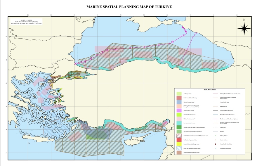
To additions to the map for the Marine spatial planningpresented and testified to UNESCO and who captures her doctrine “Blue Homeland”proceeded the Turkeywanting to show that it reacts directly to the introduction of Greece of the Southeast Cyclades Marine Park, again challenging Greek sovereign rights.
So she released the map of her own Marine parks, which he had announced and captured on the overall map of the MSS, avoiding blatant challenges such as the inclusion of “gray zones” in marine parks, as the international climate does not allow such moves that would constitute a major challenge for stability in the area.
The two controversial areas of the map of her marine parks Turkey they concern the Northern Aegeanthe area between Lemn and Samothraceand all the area around Castellorizou up to Rose.
The Greek Foreign Ministry speaks of unacceptable, unilateral and illegal action
“Unacceptable, unilateral and illegal action that does not produce any legal effect against Greek sovereign rights,” the Greek Foreign Ministry described the announcement of “maritime parks” in non -demarcated areas outside Turkish territorial waters. Recalling that Turkey has announced the designation of two maritime protected areas following the Greece initiative, the Foreign Ministry notes that this was “in international waters of the Aegean and the Eastern Mediterranean”.
The Greek side notes that the Turkish energy “shows a complete lack of respect for international sea law”.
“The Greek government is constantly and consistently acting to protect the rights of our homeland and the viability of our seas and reminds us that reflective actions of vacant content put up good neighborly relations between the two countries,” the statement concludes.
In detail the announcement of the Ministry of Foreign Affairs
Following Greece’s initiative to establish national maritime parks in the Ionian Sea and the Aegean Sea, in Greek domination, Turkey today announced the designation of two maritime protected areas and in international waters of the Aegean and the Eastern Mediterranean.
The announcement of “maritime parks” in non -demarcated areas outside Turkish territorial waters is unacceptable, unilateral and illegal energy that produces no legal effect over Greek sovereign rights and shows complete lack of respect for international law.
The Greek government is constantly and consistently acting to protect the rights of our homeland and the viability of our seas and reminds us that reflective actions of empty content place the good neighborly relations between the two countries.
Parks beyond the territorial waters
From the first study of the two maps, it is obvious that Turkey, in violation of the principles governing the process of establishing maritime parks and taking initiatives and actions to protect the marine environment, establishes parks that extend beyond its territorial waters. And they relate to marine areas related to Turkey claimed by Turkey EEZ, at the expense of Greece, with its own arbitrary and unilateral interpretation of sea law.
In addition to the overrun of territorial waters, in the North Aegean, Turkey sets the midline of the marine park as an outer boundary of the marine park, as it perceives it, between the “continental coasts” of the two countries, thereby ignoring the existence and influence of the Greek islands in the marine zones. And the marine park follows Turkey’s firm claim on Greek continental shelfas it had already been stated in the 1970s with the granting of licenses for TRAOS.

Excludes Kastelorizo
As far as Kastelorizo region is concerned, Turkey excludes the island for obvious reasons, limiting it to 6 nm territorial waters to show that the island is isolated from the Dodecanese and has no influence in sea zones. Thus, and with the marine parks, as it had done in the past with the issuance of illegal licenses for investigations by the Turkish state company TRAO (2012), Turkey is also trying to impose in the field that Kastelorizo is a special, isolated case, which in a future delimitation will not have any influence. Therefore, there will be no Greek EEZ in the Eastern Mediterranean, except Turkish. This, of course, is also linked to the demand of Turkey to limit the Greek EEZ to 6 nm territorial waters. east of Rhodes, Karpathos, and follow the line of the Turkish-Libyan Memorandum, with the external boundaries of the Turkish EEZ as filed unilaterally to the UN (2020).
Also, on the map presented by Turkey it is characteristic that Kastelorizo appears without even a border line that would capture the 6 nm territorial waters. Also, the Turkish map does not capture the boundaries of 6 nm territorial waters. of the Greek islands against the Turkish coast, in the context of the perception that there are no maritime borders in the Aegean between Greece and Turkey.
Turkish sources have stated in the East that the number of these areas would rise in the future in every sea, without blocking the activities of the relevant economic sectors, and reminded that International Maritime Law encourages cooperation between coastal states in semi -seas, including the Aegean Seas, including the Aegean Seas, Greece and the creation of an Aegean.
