
Culminates today (09.07.2025) the heat in our country. The extraordinary worsening card time issued by the NMS warns of extreme temperatures and strong winds shortly before the temperature dives up to 10 degrees Celsius.
The heat will pound our country all day. The highest temperature will be 41 degrees that will put the Peloponnese in the oven. On the other hand, very powerful winds that will blow up to 7 beaufort, will compose an explosive “cocktail” for the weather, soaring the risk of fire, mean “red” alarm in several areas.
What does the EMY Extraordinary Bulletin provide:
Very high temperatures They are foreseen in the eastern continents and the Aegean. The maximum prices will arrive:
a) to east them 38 to 40 and in eastern solids and East Peloponnese Probably locally 41 degrees Celsius.
b) to nIsia of the Eastern Aegean, the Dodecanese and Crete Locally 37 to 38 and probably 39 degrees Celsius.
Strong west winds will blow from noon to central and southern mainland, Very strong northwest winds will prevail from the afternoon to Ionian and western continents and from early night in the west and in the Central Macedonia, Thessaly and Sporades, Very strong northeast winds will prevail at night to Thursday at Eastern Macedonia, Thrace and the northeast Aegean.
See which areas will “burn” today:
“Winds winds will trigger the atmosphere on Wednesday”
George Tsatrafyllias posted on social media for the Foehn Effect that will hit our country today.
The well -known meteorologist explained that winds that are warm and dry would launch in 39 degrees Celsius the temperature to Central Macedonia, Evros, Thessaly, Fthiotida, Boeotia, Euboea, and eastern Peloponnese.
At the same time to Eastern Peloponnese, Thessaly or Central Greece can create FOEHN phenomena.
His post:
“Foehn effects will trigger the atmosphere on Wednesday. Good morning! Difficult (Pymeteorologically) will be the next 48 hours for our country since in addition to the high temperatures that will occur, strong winds will blow east of Pindos, Taygetos (and other mountaineers), which can be created by Foehn, such as Fo Attica).
The areas that will occur on Tuesday high temperatures (39-41 degrees) are: Central Macedonia, Evros, Thessaly, Fthiotida, Boeotia, Euboea, Attica (about 39) and Eastern Peloponnese. On Wednesday high temperatures (37-38 degrees) will occur in the same areas.
What are Foehn Winds:
Foehn winds are warm, dry and downhill winds that descend from the slopes of a mountain and can significantly increase the risk of fires, especially in summer.
- They dry the vegetation very quickly, making it extremely flammable.
- Raise the temperature in the area.
- They throw the moisture of the air, which facilitates the spread of fire.
- They enhance the power and speed of fire, as they are strong winds.
The temperature (8-10 degrees) fall significantly on Thursday and the north is reinforced. New rise (not excluded heat) from Sunday 13/7 “.
Weather forecast for today
In general, a few clouds and local rains in the northwest are forecast for this morning. In the rest of the country the weather will be cloudy.
Local clouds will develop in the northern continents from noon hours, so they are likely to occur temporary ravine or isolated storms mainly in Macedonia and Thrace.
The winds They will blow west northwest 3 to 5 and in the central and south local 6 beaufort, gradually in the Ionian Sea, the mainland and the northern Aegean north to 6 to 7 beaufort.
OR temperature It will fall slightly in the western continents and the Ionian Sea, but in the rest of the country it will be maintained high. It will reach the eastern continents locally 38 to 40 and possibly 41 degrees, in their other continents 35 to 37 degrees, in the eastern Aegean islands, the Dodecanese and Crete 37 to 38 and possibly 39 degrees and in the rest of their island country 33 to 36 degrees Celsius.
Attica
Weather: Clear.
Winds: West northwest 3 to 5 and gradually local 6 beaufort.
Temperature: from 25 to 39 degrees Celsius, in coastal the maximum 2 to 3 degrees lower.
Thessaloniki
Weather: Generally cloudy, with temporary clouds and probability of local rainwater in the afternoon – afternoon.
Winds: From west directions 3 to 4 beaufort, from early in the evening northwest to 6 to 7 beaufort.
Temperature: from 23 to 38 degrees Celsius.
Macedonia – Thrace
Weather: Initially generally cloudy, local clouds will develop from noon hours and temporary rainstorms or individual thunderstorms are likely to occur.
Winds: From west directions 3 to 5 beaufort, from early in the night of north 6 to 7 beaufort.
Temperature: from 22 to 39 degrees Celsius. In Western Macedonia the minimum 3 to 4 degrees lower.
Ionian Islands – Western Solidarity – West Peloponnese – Epirus
Weather: In Epirus a few clouds locally increased in the morning with the possibility of temporary local rain. In the rest of the areas generally cloudy weather.
Winds: West northwest 3 to 5 and gradually to 6 and local 7 beaufort.
Temperature: from 23 to 34 and continental to 36 degrees Celsius. Inside the continent the minimum 3 to 4 degrees lower.
Eastern Sterea – Euboea – Eastern Peloponnese
Weather: Generally cloudy.
Winds: West northwest 3 to 5 and gradually to 6 and local 7 beaufort.
Temperature: from 24 to 39 to 40 and locally to 41 degrees Celsius.
Cyclades – Crete
Weather: Generally cloudy.
Winds: West northwest 4 to 6 and gradually in Crete local 7 beaufort.
Temperature: from 24 to 36 and in Crete locally up to 38 and possibly 39 degrees Celsius.
Eastern Aegean Islands – Dodecanese
Weather: Generally cloudy.
Winds: In the northern variable 3 to 4 beaufort and from the night northeast to 6 to 7 beaufort. In the south west northwest 4 to 5 beaufort.
Temperature: from 23 to 37 to 38 degrees Celsius.
Thessaly
Weather: Generally cloudy.
Winds: West northwest 3 to 5 and gradually to 6 and local 7 beaufort.
Temperature: from 23 to 40 and in Sporades to 36 degrees Celsius.
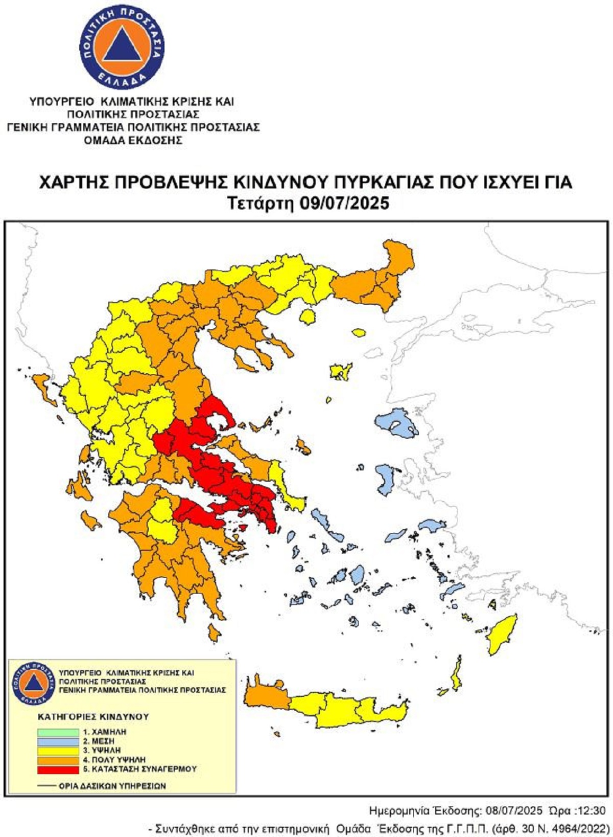
Extreme risk of fire manifestation
Wednesday (9/7/25) is extremely serious according to the official risk prediction map released by the General Secretariat for Civil Protection, since in There will be many areas of the country alarm, with danger category 5, with extreme fire conditions.
Regions such as the Attica, Central Greece, Peloponnese and Thessaly are in “Red”while other areas, island and continental, from Western Greece to Macedonia, Thrace and Cretethe risk of fire remains very high in class 4.
Increased temperature, strong winds and drought will create extreme conditions that favor the rapid spread of fire fireplaces.
Specifically, the areas with extreme risk of fire are: Attica, Boeotia, Fthiotida, Magnesia, Corinthia.
Very high and high risk, there is a whole of the rest of the mainland and in several areas of the island.
Civil Protection Authorities are on increased readiness and calling on citizens to show responsibility, avoiding any action that could cause a fire. Firefighters, police are on the alert, and army officials will patrol all night in suburban forests and other critical points across the country.
As civil protection noted, everyone’s cooperation is critical, as in such conditions even a little negligence can lead to serious consequences for the natural environment, property and security of residents.
See from the Windy map in what areas there is a risk for fire event:
Weather forecast for the next few days
Prognosis for Thursday 10-07-2025
In eastern Macedonia and Thrace a few clouds in places increased with the possibility of temporary rainwater until the afternoon. In the rest of the country generally cloudy weather with a few temporary clouds in the midday – afternoon hours in the continental mountains.
The winds will blow from northern directions 4 to 6 and locally 7 beaufort. In the early hours of the morning in eastern Macedonia, Thrace and the northeast Aegean, strong northeast winds of 6 to 7 beaufort will blow.
The temperature will drop and only in the southeast will remain high. It will reach their continents 31 to 33 and locally in the eastern continents, the islands of the eastern Aegean and the Dodecanese 34 to 35 degrees and in the rest of their island country 28 to 31 and locally in southern Crete 32 to 33 degrees Celsius.
Prognosis for Friday 11-07-2025
Generally cloudy weather. From the noon hours on the continents, mainly mountainous, local clouds will develop and temporary rainstorms will occur and individual storms may occur in the northern mountains.
The winds will blow from northern directions 3 to 5 and locally 6 beaufort.
The temperature will drop slightly to the southeast while the rest of the country will not make a significant change.
Prognosis for Saturday 12-07-2025
Generally cloudy with a few local clouds in the north. In the afternoon – afternoon, temporary clouds will develop on the continents, mainly mountainous, with local rainstorms and possibly individual storms in the mountains.
The winds will blow from north directions 3 to 5 and in the Aegean local 6 beaufort.
The temperature will not note a significant change.
Prognosis for Sunday 13-07-2025
Generally cloudy weather with temporary clouds in the midday – afternoon hours in the continental mountains.
The winds will blow from northern directions 3 to 5 and in the Aegean 6 local 7 beaufort.
The temperature will rise slightly.